
This article is an overview of everyone that a geomodeller would interact with through the course of a project, be they data providers, stakeholders or product owners. The list of specialists will probably grow with time, and the interactions between them will also grow.
All of the roles mentioned here will be used in the series “Bridging the Knowledge Gaps” and “Network Builder”. It is also worth mentioning that the same person can have multiple roles within a project, I myself have been a geologist/geomodeller, I have worked with a team lead/geologist, and have even seen a project where one person was project manager/seismic interpreter/geologist/geomodeller/part-time reservoir engineer/amateur economist.

The interactions are ones that I have experienced, if there are any others that you think that could be worth adding or discussing then please drop me an email and I will be happy to have a chat about it.
Geomodeller
I’d like to think that geomodellers are the subsurface version of “Jack-of-all-trades”, as they need a basic knowledge of all the inputs and data that they will receive and an understanding of their deliverables and how they will be used.
They need to be flexile in their approach to geomodelling, as no project is the same, be that due to the geological concept model, the data set available, or the task being undertaken.
Project Manager
I was unsure if project manager should be included in the list of roles that a geomodeller interacted with, but after some thought it became clear that they are probably the most important contact within a team. The project manager (or team lead) is usually the person who provides the team with its task, and the time frame in which it should be completed.
The interaction between project manager and geomodeller is probably the most difficult to describe, as each management style is different (there are whole sections dedicated to management books in bookstores) and each project is different.
I think range of styles can be plotted on a set of axis; Influence & Involvement. The end members of Influence are “control”, where the project manager gives complete instructions on what to do, and “freedom”, where the project manager gives the geomodeller full choice in how to approach the task. Involvement’s end members are “daily”, where the manager wants frequent updates (think micro-manager) and “deliverable”, where the project manager only wants milestone updates.
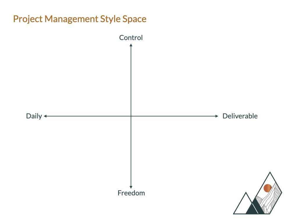
The only places in this plot where the management style could be seen as poor are the combination of 2 extremes, these are listed below:
- Daily-Control could feel like they are constantly telling you what to do.
- Daily-Freedom could feel like you are always explaining your methods and thoughts.
- Deliverable-Control could seem quite detached, a “do this and tell me later” approach that might not work if there are any major difficulties or issues with the project.
- Deliverable-Freedom could also appear very detached from the project, and may lead to poor motivation.
Geologists
If the project manager provides the most important element to the team (the task), then the most important input to the geomodeller comes from the geologist; the geological concept model.
In projects that are young in terms of data availability, the concept model is the driving mechanism behind how the model is constructed, and as more data is acquired than the model has to change to adapt to these. It is also worth noting that in the initial stages of a project, there could be more than one concept model, it is part of the geologist’s role to incorporate data as it is collected to define a single concept model.
Seismic Interpreters
I have decided to have seismic interpreter as a separate entry to Geophysicist after working with someone who used the term “geological interpreter” and I think that this fit this interaction better then the more encompassing term geophysicist.
This role provides the parts that make the box of the reservoir and aquifer; the horizons and faults. These can be in the form of surface, points or sticks, and can be the dataset that requires the most refining and editing for us in a geomodel (I must admit feeling a little guilty after informing someone that I have taken their 200+ faults and reduced it down to 7).
Petrophysicists
If the seismic interpreter helps building the box, then the petrophysicist provides the data used to fill it!
Petrophysicist will provide the well data that is used to populate the geomodel with values, and the more data there is available the more important their role is. One of the most interesting things that a geomodeller must decide on is the transition from concept driven modelling to data driven modelling. The data can come from many different sources, and the geomodeller should be involved in the co-ordination, distribution and discussions involved in the team, acting as a translator between specialities.
Specialist Geologists
I have found out that there is very little direct interaction between specialist geologists and geomodellers, and the most common interaction is how to display results. As shown in the diagram at the top of the article, the information from specialist geologists is usually provided to the geologist to help them with the concept model.
Some of the data that can be used to guide the concept model includes:
- Biostratigraphy
- Chemostratigraphy
- Structural Reconstructions
- Stress Modelling
- Oil fingerprinting
- Heavy metal studies
Geophysicists
That is capital G Geophysicists!
They provide seismic datasets that are either extracted from existing seismic data or a from a combination of datasets. Below is a list of some of the types of data they can provide:
- Acoustic Impedance
- VpVs
- VClay
- Wedge Models
- Spectral Decomposition
The data that they provide can be extremely useful, and can really help with the distribution of properties within the 3D model. However, some of the terminology and methodologies can be very daunting so spending a little time insuring that everything is clear and understood is key.
Reservoir Engineers
Reservoir Engineers, for the most part, are the client for the geomodel and are the role that provide some of the most important feedback in the form of pore-volume and permeability multipliers, the interpretation of these could be an article in its own right.
When their feedback is provided the geomodeller must review their model, then co-ordinate with the geologist, geophysicist and petrophysicist to figure out what part of the model can be changed, and more importantly, if it can be changed. This is probably one of my favourite parts of a long term project, problem solving what the multipliers could be highlighting, and figuring out which roles support will be needed.